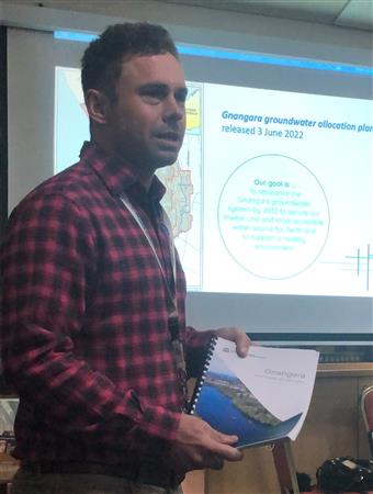
 Michael Hammond is the Principal Water Planner at the Department of Water and Environmental Regulation, and he came along to tell us all about the Groundwater Re-balancing Plan that exists for the Gnangara Groundwater System and that is in response to climate change. The System consists of the surface level wetlands, lakes etc. (which help to moderate temperatures around Perth), the Leederville Aquifer beneath the Swan Coastal Plain west of the Darling Scarp, and below that the Yarragadee Aquifer which is located hundreds of metres below ground level. Michael explained that the Plan came into effect on 3 June this year and it supersedes a plan which was instituted in 2009 and which included a desalination plant. The Plan also embraces a longstanding Ministerial Statement that sets water level criteria for 30 specific sites in the area. The Plan sets out how groundwater use will be reduced over the next 10 years in order to secure what is the lowest cost and most accessible water source for Perth, and the water level criteria are designed to protect important groundwater-dependent ecosystems, such as wetlands, bush land areas, and certain fauna. The System provides almost half of all the water used in the Perth metropolitan area each year, and this should be viewed in the context that rainfall has declined by around 15% in the last 50 years or so. This trend is expected to continue. Groundwater also supplies 1 in 4 households with garden irrigation as well. There are 50 monitoring wells located across the System to keep an eye on things. Michael’s talk was most informative and very interesting indeed.